Australian police introduce laser-mapping to crime scene analysis
Police in Queensland, Australia are starting to use environment-scanning equipment designed for caving and mine-mapping to create 3D diagrams of crime scenes.
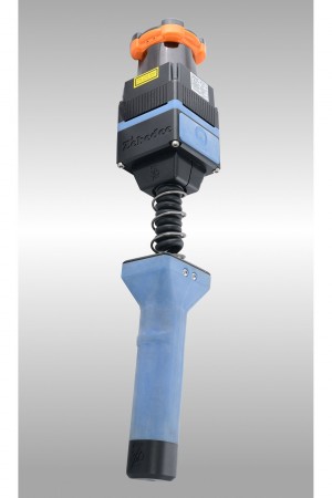
The Zebedee handheld mapping scanner was developed by CSIRO, Australia’s national science research agency and has previously been used to map the interior of the Leaning Tower of Pisa, as well as other culturally significant locations and mining sites. Now, for the first time, officers will be able to walk through a crime scene with a scanner and capture data, which they’ll be able to use to generate a 3D map in about 20 minutes.
“The benefits of this new technology will reduce interference at a scene, save time, and allow access to previously hard-to-reach areas such as step declines and bushland,” said Queensland Police Commissioner Ian Stewart in a statement.
Read 5 remaining paragraphs | Comments
![]()
     |